COASTAL
CAROLINA SCIENTIFIC DIVING ASSOCIATION
8th
Annual Scientific Diving Symposium
~~~ Friday, March 24th, 2017 ~~~
Hosted
by NOAA’s Beaufort Lab on Pivers Island, NC
MORNING SESSION (DSO Discussion Group): Open to Dive Safety Officers, Dive Supervisors,
and Dive Program Administrators. Location – NOAA Main Auditorium.
8:30-9:00
Late Registration, Hospitality, Meet and Greet
9:00-11:30 DSO Discussion Group
- Program
Reciprocity Requirements – Brian Degan & Steve Broadhurst (25 minutes)
- Rick Gomez
– President AAUS “The Future of
AAUS” (25 minutes)
- SHORT
BREAK (5 minutes)
- Dr.
Peter Buzzacott – DAN “Hazards of
Underwater Photography” (25
minutes)
- SHORT
BREAK (5 minutes)
- Dr.
Jake Freiberger – Duke Dive Medicine “Diving Narcosis Study” (25 minutes)
- SHORT
BREAK (5 minutes)
- Ursula Ehrenfeld – DAN “DFA Pro eLearning Format”
(25 minutes)
LUNCH 11:45-12:45 at Duke Marine Lab
Cafeteria - $7.45 per person (CASH ONLY)
AFTERNOON
SESSION (Scientific Presentations): Open to everyone.
Presentations by Scientific Divers moderated by Jenny Vander Pluym – NOAA.
Location – NOAA Main Auditorium.
1:00-1:10 Brad Berry, NC Division of
Marine Fisheries: “NCDMF Limited Visibility Diving
Approaches”
1:15-1:30 Claire
Rosemond, UNC-Institute of Marine Sciences: “Inclusion
of buffer zones
between artificial reefs to more effectively enhance fisheries”
1:35-2:00
John W. Morris III, NCDNCR-Underwater Archaeology Branch: “Condor: North Carolina’s First Heritage
Dive Site”
2:05-2:15
Jim Hench, Duke University Marine Laboratory: “Field measurements of topography and hydrodynamics on coral reef
patches”
2:20-2:35
BREAK
2:35-2:45 Carol
Price, NC Aquariums Division: “Overview
of the NC
Aquariums vision for our conservation research program and partnership with NC
State University”
2:50-3:05 Avery
Paxton, UNC-Institute of Marine Sciences: “Convergence of fish
communities between a newly deployed and an established artificial reef
occurred over five months and along a distinct trajectory
North Carolina’s Artificial Reef Program”
3:10-3:30 Doug
Kesling, Independent Contractor: “A Brief Look at
Emerging Technologies for Marine Science and Ocean Exploration: Past and
Present”
3:50-4:05
Erin Burge, Coastal Carolina University: “SharkCam: Using a publically accessible underwater streaming webcam in
research and teaching”
4:10-4:25 Sarah
Groves, NOAA: “Community structure and coral growth in
mesophotic habitats surrounding St. Thomas, US Virgin Islands”
4:30-4:55 Melissa
LaCroce, UNCW: “Seasonality of Epibenthic Organisms on the Hard
Bottom at Five Mile Ledge in Onslow Bay, North Carolina”
5:30-7:00
HAPPY HOUR at BEAUFORT GROCERY -
117 Queen Street, Beaufort, NC (One block off Front
Street) Cash Bar –
Appetizers Provided!
Thank you to the host of this year’s symposium:
And very special thanks to:
Abstracts
NCDMF
Limited Visibility Diving Approaches, Brad Berry, NC Division
of Marine Fisheries
North Carolina
Department of Environmental Quality, Division of Marine Fisheries utilized
Scientific Divers to work in coastal waters for the Oyster Sanctuary and
Artificial Reef Program objectives. One priority has been water quality
monitoring using the YSI EXO 2 SONDE recording dissolved oxygen, salinity, and
temperature values at desired intervals. Techniques and procedures that
facilitated safety in limited visibility diving conditions, water quality SONDE
deployment and recovery applications, and scientific diver in training
certification can be interchangeable in other Scientific Diver functions and
approaches.
Inclusion of buffer zones between artificial reefs to more effectively
enhance fisheries, Claire Rosemond, UNC-Institute of Marine Sciences
Artificial reefs are deployed world-wide to enhance
fisheries. Placement of new artificial reefs relative to nearby existing reefs
influences fish communities, yet no quantitative guidelines exist for buffer
distances between reefs. We determined buffer zones around reefs where
placement of new reef structures should be avoided. We sampled fish communities
and environmental variables on twenty-four temperate reefs, including
artificial and natural reefs. We surveyed 30 m on reefs and along three
transects of increasing distance away from reefs into contiguous sand habitat:
0-30 m, 30-60 m, and 60-90 m away from reefs. Fish abundance, biomass, species
diversity, species richness, and species evenness decreased significantly from
reefs to 30-60 m away from reefs and remained low 60-90 m away from reefs. Fish
community composition shifted gradually, with the community composition
on-reefs most dissimilar to the community composition on sand habitat farthest
from the reefs. A buffer of 60 m (30 m around existing reefs plus 30 m around
new reefs) and 120 m (60 m plus 60 m) between reefs would encompass ~80% and
~91%, respectively, of fishes occupying contiguous sand habitat around each
reef. Future artificial reef deployment should include these buffer zones
between reefs to more effectively enhance fisheries.
Condor:
North Carolina’s First Heritage Dive Site, John W. Morris III, NCDNCR-Underwater Archaeology Branch
During the four-year campaign by the Union Navy to close the
port of Wilmington to the Confederacy over forty vessels were lost by both
sides. The blockade runner Condor was lost on the night of 1 October 1864
running into New Inlet. Swerving to avoid the grounded runner Night Hawk,
Condor ran at full speed onto the inlet bar and stuck fast. The Confederate
spy, “Rebel Rose” O’Neal Greenhow, attempting to avoid capture, lost her life
when the small boat carrying her ashore capsized in the heavy swells. Condor
was partially salvaged and eventually destroyed by shell fire from both sides.
Condor was built by Randolph, Elder and Company, of Govan, Scotland for
Alexander Collie and Company specifically to run the blockade. At 221’ long by
28’ in beam, Condor epitomized the search for speed under steam. The wreck site
was thoroughly documented from 1994-1996 with updates completed in 2016. To
date Condor remains the world’s best preserved blockade runner. Since 2015 The
Underwater Archaeology Branch (UAB) of the North Carolina Office of State
Archaeology has worked with the local dive community to turn this well-preserved
blockade runner into North Carolina’s first true Heritage Dive Site. Heritage Dive Sites, in conjunction
volunteer diver training programs in other states and countries have
successfully created a shared sense of stewardship and responsibility. UAB is
now working to create the same sense of public stewardship for North Carolina’s
rich maritime heritage starting with Condor as the first “In Sea Museum”.
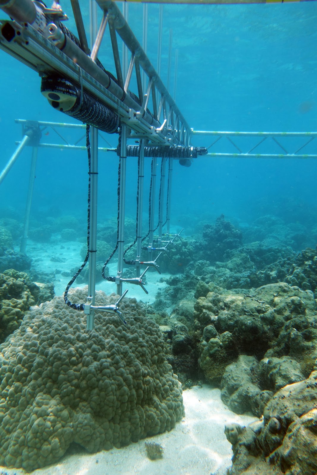
Field
measurements of topography and hydrodynamics on coral reef patches, Jim Hench, Duke University Marine Laboratory
Bottom
topography on reefs varies at a wide range of spatial scales and affects many
physical, chemical and biological reef processes. Reef structure provides
habitat and refuge for many fish and invertebrate species. Rough topography
also exerts drag forces on water as it moves across reefs and the interaction
between flow and topography generates turbulence and mixing. Knowledge of
bottom topography is therefore important for predicting circulation, transport,
and dispersion on reefs. Reef structure can change significantly over time as
structure is destroyed and redevelops from disturbances; it is therefore also
important to document reef structure and its evolution through time. We
conducted a series to field tests to evaluate an ultra-high frequency scanning
sonar system (Blueview BV5000) to measure small-scale 3D topography. The sonar
was deployed by divers on a bottom-mounted tripod, and cabled back to a small
boat. The rotating sonar collected 360 degree, 200 m^2, circular swaths of
bottom topography. Our initial tests used arrays of objects with simple
geometry and known dimensions. We also tested the system on complex natural
coral reef substrates. We are currently analyzing the data to determine the
accuracy of the system, and assessing how data quality varies with factors such
as distance from sonar head, number of registration points, and topographic complexity.
Overview of the NC Aquariums vision for our conservation
research program and partnership with NC State University, Carol Price, NC Aquariums Division
An overview of
the NC Aquariums vision for our conservation research program and partnership with
NC State University.
Convergence
of fish communities between a newly deployed and an established artificial reef
occurred over five months and along a distinct trajectory
North Carolina’s Artificial Reef Program, Avery Paxton, UNC-Institute of Marine Sciences
Numbers of human-made, artificial reefs in the oceans are
increasing, yet questions remain of how fish colonize these novel reefs. Here,
we tested 1) whether the fish community on a newly-deployed artificial reef
converged with the community on an adjacent, established artificial reef over
time and 2) whether fish colonization of the new artificial reef exhibited a
predictable successional sequence. To answer these questions, we simultaneously
collected time-lapse videos of fish colonizing a new artificial reef and those
inhabiting a nearby (438 m away) established (> 20 yrs old) artificial reef
over time. We found that fish community composition on the new artificial reef
converged with the community composition on the established artificial reef
over five months. Community development on the new reef followed a distinct
successional trajectory: schooling, planktivorous baitfish initially colonized
the reef in high numbers, whereas demersal fishes exhibited delayed
colonization. These findings suggest that fish colonization of artificial reefs
follows a specific trajectory and that community convergence between reefs can
occur over short temporal scales given similar environmental conditions. Our findings on fish colonization of artificial
reefs are important to consider when deploying additional structures, such as
infrastructure associated with offshore energy, in the marine environment.
A Brief
Look at Emerging Technologies for Marine Science and Ocean Exploration: Past
and Present, Doug Kesling,
Independent Contractor
Historical look back at evolving technologies for undersea
exploration with the introduction of new and novel approaches to the
technological challenges for the 21st century.
SharkCam: Using a publically accessible underwater streaming webcam in
research and teaching, Erin
Burge, Coastal Carolina University
In August 2014, View Into the Blue (VITB), Teens4Oceans
(T4O), Frying Pan Tower (FPT), and the Annenberg Foundation’s Explore.org
project installed an underwater streaming webcam, SharkCam, at the Frying Pan
Tower, 60 km off the coast of southeastern North Carolina. The camera
installation and associated infrastructure are maintained by the partner
organizations and volunteers. The camera is attached near the bottom in 15 m of
water. The camera surveys the 3-dimensional structure that the tower legs
represent and is adjacent to an expansive area of natural hard-bottom reef.
Both these man-made and natural structures are important areas of high fish
diversity. Public viewers, undergraduate students and professional researchers
have so far identified over 90 species of fish that frequent the area. The
camera feed is available live over the web and has an invested public
viewership. Since the project went live the camera feed has had over 898,000
public views, and the associated discussion forum has received almost 33,000
comments. The camera is utilized for research by cohorts of students that data
mine the archived footage for occurrence and relative abundance information on
the fish assemblage. An identification guide book has been developed using
still photos and excerpted video clips with detailed species descriptions,
commonly confused species, and relative size and abundance information.
Community structure and coral growth in
mesophotic habitats surrounding St. Thomas, US Virgin Islands, Sarah Groves, NOAA
Mesophotic coral ecosystems (MCEs) are deep (>30m),
light-dependent communities that are abundant in many parts of the global
ocean. MCEs are potentially connected to shallow reefs via larval exchange and
may act as refuges for reef organisms. However, MCE coral community recovery
after disturbance, and thus, community resilience, are poorly understood
components of their capacity as refuges. To assess the potential for disturbance
and growth to drive community structure on MCEs with differential biophysical
conditions and coral communities, we collected colonies of Orbicella franksi
and Porites astreoides and used computerized tomography to quantify
calcification. Growth rates of corals in divergent mesophotic habitats may be
species specific, and habitat forming O. franksi have slow and consistent
growth rates below 30 m, regardless of habitat. Slow skeletal growth rates in
MCEs suggest that rates of recovery from disturbance will likely also be slow.
Localized buffering of MCEs from the stressors affecting shallow reefs is
therefore crucial to the long-term capacity of these sites to serve as refugia,
given that skeletal extension and recovery from disturbance in MCEs will be
significantly slower than in shallow reefs.
Seasonality of Epibenthic
Organisms on the Hard Bottom at Five Mile Ledge in Onslow Bay, North Carolina, Melissa
LaCroce, UNCW
Natural and unnatural disturbance events change benthic
marine habitats by dislodging and smothering sessile species. The increasing
frequency and magnitude of storm events, intensity of grazing activity, and
anthropogenic sand displacement projects will affect epibenthic marine
communities, like those of the hard bottom ledges in Onslow Bay, NC. When a
disturbance occurs, epibenthic species are removed and substrate is exposed or
excess sand covers existing life suppressing its development. This combined
with the warming waters of the eastern North Atlantic creates an opportunity for
species previously found at different sites and depths, and non-native benthic
organisms to colonize the exposed area. Onslow Bay’s unique geographical
location makes it the northern and southern limit for many marine organisms.
Therefore, the composition and dynamics of this epibenthic community could be a
proxy for the future structure of more northern marine habitats along the East
coast as water temperatures rise. This study’s objective is to determine the
seasonal dynamics and spatial scales of epibenthic species recruitment on North
Carolina hard bottoms. Seasonal collections and photos of control and
seasonally cleared quadrats from three replicate sites within a nearshore hard
bottom ledge system in Onslow Bay, NC, are being investigated with SCUBA
utilizing NITROX.